Find out how a Municipal Comprehensive Review (MCR) process affects your community growth.
The MCR process is part of an Official Plan review. To simplify, think of it as a growth management puzzle. The frame of the puzzle is an urban boundary. Between the frame there are pieces to fit together to create communities with housing, transit, schools, jobs, and green space. The MCR process takes the forecasted growth for a region and figures out how and where new development can best fit in a municipality.
Note: A municipal boundary is different than an urban boundary. Between the municipal boundary and an urban boundary there may be farms, forests and small rural land uses. Expansion of the urban boundary paves over these important land uses.
The process of fitting the pieces together requires information and research.
Many questions need to be asked, like whether towns and cities have the water and sewers to accommodate housing? How people can move from work or school to home? Where people can work or shop? What towns have vacant land or redevelopment areas?
There are several pieces to the MCR process. These include:
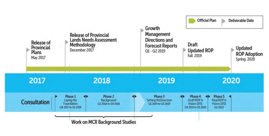
In 2014, York Region embarked on a MCR process to review of the Region’s population and employment forecasts, land budget and Regional Official Plan policies. Above is York Region's five-stage consultation process in working towards this goal. Learn more. Photo credit: York Region.
- Calculating the land budget, which determines how much new land will be needed to accommodate people and jobs. This looks at opportunities to fill in empty lots and redevelop single-use public land, like parking lots at a GO station. Municipalities cannot require private landowners to build up and redevelop but they can identify an area for intensification, change the zoning and put incentives in place that make redevelopment attractive.
- Identifying (if needed) where to expand urban boundaries.
There is a concern that the MCR process will be used to justify urban expansion onto farmland rather than used to identify where to grow up. Expanding urban boundaries requires a number of studies that should be closely scrutinized. Building up in our existing urban areas needs to be the first consideration if the Growth Plan is going to be effective.
The outcome of the MCR process brings regional (upper-tier) Official Plans into conformity with the Growth Plan; ideally moving us away from sprawl development on farmland to accommodate more growth in existing urban areas.
At the regional level, that means figuring out where growth can be placed to provide more housing choices, transit, public services (like schools and hospitals), sewage systems, and determining how the community layout works best. Municipal decisions on how we grow and where we grow affects rural areas too: local farming, wildlife habitat, water and natural heritage systems, and travel patterns. In short, the future health and prosperity of our region.
To determine how to accommodate people and jobs in urban areas, a number of background studies and strategies must be prepared by the municipality.
These MCR studies include:
- An intensification strategy that identifies areas that can accommodate further development within an existing urban area. This could include vacant lots, underutilized land, basement apartments, laneway housing, and converting strip malls into mixed use developments.
- An employment strategy that determines what types of businesses and shops the community can attract and retain.
- A housing strategy that identifies the current housing mix and what type of housing are missing and needed.
- An analysis to justify why existing employment areas might be converted to non-employment uses.
- An analysis to justify any loss or changes to the Natural Heritage System or Agricultural System due to a boundary expansion.
- Infrastructure plans for water, wastewater and public transit.
- Transportation demand management.
Settlement Boundary Expansions:
The Growth Plan makes provision for municipalities to expand their settlement boundaries. Under normal circumstances, this happens as a result of an MCR process. The expansion will be restricted to the amount of land required for the population and growth to 2041.
The provincial Land Needs Methodology must be used for this analysis.
There are a number of tests that must be met prior to a municipality including a boundary expansion in their Official Plan. Specifically, changing the boundary must be justified by undertaking a number of studies that determine if there is existing or planned infrastructure capacity (sewer and water) and if required, upgrading the infrastructure and determining if it is financially viable. Typically, an Environmental Assessment will be required to extend services to bring greenfield lands into an urban area.
A boundary expansion should avoid the Natural Heritage Systems and prime agricultural areas where possible. Once the MCR process is complete, the region will need to submit their plan to the province for approval.
Citizens should contact their regional municipalities to stay informed about boundary expansion requests.
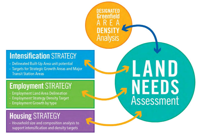
These are some of the key inputs identified in York Region's Land Needs Assessment. Learn more. Photo credit: York Region.
Close the Loopholes
There are four loopholes that undermine
the intent of the Growth Plan.
1. In the outer ring, beyond the Greater Toronto Area, the Growth Plan continues to allow low density housing in rural areas without municipal servicing (water and sewer). Neptis Foundation research shows how these loopholes can facilitate expensive growth that is not consistent with smart growth.
2. Another loophole allows whitebelt lands, land between the Greenbelt and the inner ring urban areas, to be excluded from Greenbelt protection. Some municipalities like the Town of Oakville and the City of Hamilton have asked the province to extend Greenbelt protection to whitebelt lands, to protect water systems, nature and farmland at risk.
3. Municipalities in the outer ring of the Growth Plan request the province for lower density targets. It is crucial that a land needs assessment is done prior to any requests being considered by the province for alternative targets. More low density housing on greenfield sites can result in loss of farmland, creates more traffic, adds to municipal debt, and increases taxes and user fees.
4. Due to changes to the Growth Plan in 2019 (Bill 108), it is now possible for municipalities to expand their settlement boundaries outside of the Municipal Comprehensive review process. The new policy permits settlement area boundary expansions of up to 40-hectares in between comprehensive reviews of land budgets. Moreover, the process can be initiated either by municipal planners or private developers and there is no limit to how often a settlement boundary can be shifted in this way.
Addressing climate change in the Official Plan review:
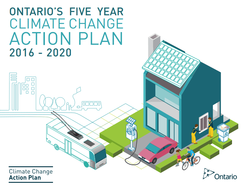
Read more about Ontario's 5-year Climate Change Action Plan. Photo credit: Ministry of Environmental and Climate Change.
The Official Plan review is an opportunity to take climate change action.
Under the newly revised Growth Plan, municipalities are required to bring climate change policies into their Official Plan. Climate change action can happen throughout a municipality as part of engineering and facilities management (buildings, pumps, vehicles), parks and parking. But planning also has an important role in making the urban form more resilient and energy efficient. As Official Plans identify goals, objectives, and policies, the more directive the Official Plan is on an issue like climate change, the better.
For example, the City of Guelph Official Plan includes climate action.
You can encourage your municipality to bring in policies such as:
- Green infrastructure requirements to minimize floods.
- Renewable energy goals that encourage district energy infrastructure.
- Urban form policies such as streets that follow a short grid pattern rather than curvilinear directions.
- A complete streets policy that requires local cycling and walking options.
- New buildings must follow a Green Building standard or LEED Gold certification.
- Set an urban tree canopy goal, e.g. 35%.
- Reduce building parking requirements where there are public transit options.
Click on the sections below for more information:
