Concrete Consequences
How building Highway 413 would put GTA watersheds at risk
Poorly planned and unnecessary infrastructure development outside of existing cities and towns has damaged ecological systems and continues to be a concern throughout these watersheds. This provincial disregard for the health of key watersheds continues as the government of Ontario continues to push for more unnecessary and environmentally harmful development projects, such as Highway 413.
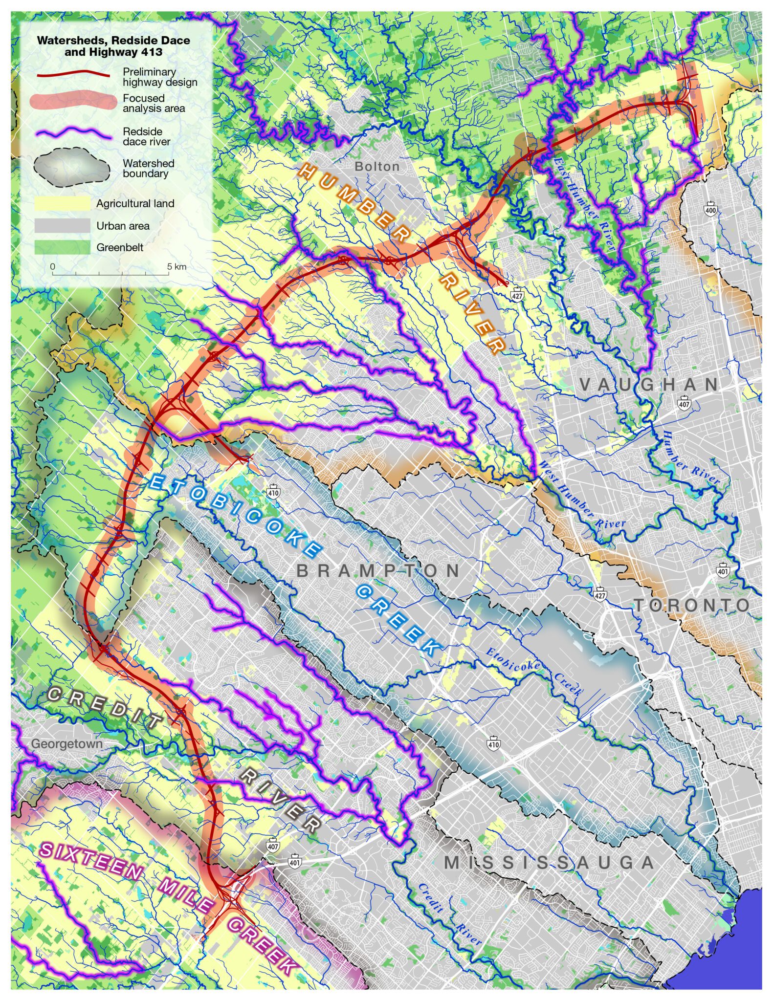
Highway 413 is an unnecessary project and will accelerate urban sprawl in the Halton and Peel regions. The government’s preferred route of Highway 413 will destroy large natural areas of forest, meadow, river and wetland habitat within the Humber River, Etobicoke Creek, and the Credit River watersheds. The lower reaches of each of these watersheds have been significantly urbanized over the past six decades, negatively impacting critical natural areas that provide ecological services and water quality. The watersheds are threatened with further degradation from this highway and the urban sprawl it will enable.


All three watersheds already face serious health risks from existing urbanization and do not meet recommended federal guidelines.
HUMBER RIVER WATERSHED

ETOBICOKE CREEK WATERSHED

CREDIT RIVER WATERSHED

If Highway 413 is built, it will deal a devastating blow to all three watersheds.
of remaining endangered Redside Dace habitat located throughout the Humber River and Credit River watersheds will be destroyed.
increase in chloride concentrations in waterways throughout the Etobicoke Creek watershed due to urbanization.
Low-density suburban sprawl is a growing concern in southern Ontario. The Ontario government is proposing Highway 413 as a way to prioritize and accelerate this type of growth onto farms, forests, and wetlands within three watersheds in the GTA.
Highway 413 will cut through three of Ontario’s watersheds: the Humber River watershed, Etobicoke Creek watershed, and the Credit River watershed. Each of these watersheds have seen a significant amount of urbanization over many decades and are threatened with the pressures of urban development and the impacts on natural heritage systems.
Highway 413 will impact each watershed by altering the natural cover and water quality levels through the areas where the proposed highway’s route will be constructed. These impacts will lead to further ecological degradation in each watershed through biodiversity loss, habitat destruction and fragmentation, increased impervious surface, and elevated concentrations of chloride in waterways due to enhanced road salting activity.
Let's take action!
© Copyright 2024 by ENVIRONMENTAL DEFENCE CANADA. Permission is granted to the public to reproduce or disseminate this report, in part, or in whole, free of charge, in any format or medium without requiring specific permission. Any errors or omissions are the responsibility of ENVIRONMENTAL DEFENCE CANADA.