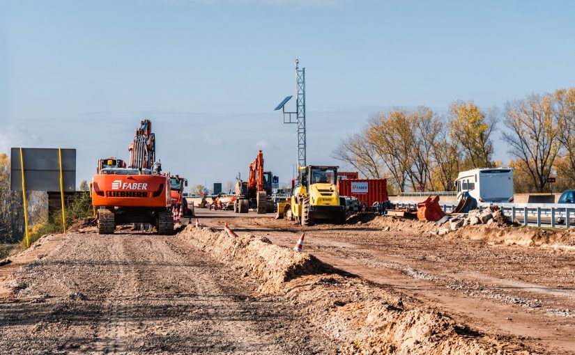
GTAH municipalities were pushed to expand their suburban boundaries by 165 km2 after the province imposed new (2019 and 2020) planning rules that were calculated to promote unnecessary sprawl development and waste development land.
Ontario has designated more than enough land to build new homes without touching the Greenbelt.
The map below shows the different land designations in the Greater Toronto and Hamilton Area (GTHA). As can be seen on the map, the GTHA now has roughly 59,000 ha of land designated for development – nearly 4x the amount needed for housing through 2051.
Map of GTHA Development Land
You can zoom in on any area of this map to see roads, rivers, lakes and cities. The colours of the map represent the different types of land designations in the GTHA.
Map design by Chris Brackley, As the Crow Flies cARTography
Hover over the legend boxes below to learn about the different land designations in the GTHA.
Click the legend boxes below to learn about the different land designations in the GTHA.

2022 Settlement Boundary Expansion (new rules)
2022 Settlement Boundary Expansion (new rules)

Additional 2022 Settlement Boundary Expansion (directly imposed by province)
Additional 2022 Settlement Boundary Expansion (directly imposed by province)
The present ON government directly forced this 7,060 ha suburban boundary expansion on GTAH municipalities.
When added to the existing supply of development land and previous boundary expansions, these forced expansions brought the supply of non-Greenbelt land designated for development to 59,000 ha.

Built Up Area 2000
Built Up Area 2000
This is land area consumed by urban development and suburban sprawl in the GTHA, up until the year 2000.

Land Consumed 2001-2019
Land Consumed 2001-2019
This land, totaling roughly 17,000 ha, was consumed by outward suburban sprawl from 2001 to 2019 (most recent data available).

Unbuilt Development Land Before 2022 Municipal Comprehensive Review
Unbuilt Development Land Before 2022 MCR
Before the present government's expansions (2022), the GTHA already had more than 35,000 ha of land designated for development, but still sitting unused. This is enough land for well beyond 2051.1

Remaining Greenbelt
Remaining Greenbelt
Lands within the Greenbelt that remain protected.

Remaining Contested Countryside
Remaining Contested Countryside
Contested Countryside (a.k.a. "white belt") is farmland, forest, wetland and habitat that is outside suburban "settlement boundaries," and thus off limits for sprawl, but does not yet have the permanent protection that is supposed to be attached to Greenbelt.2

Countryside Beyond Greenbelt
Countryside Beyond Greenbelt
These are farms, forests and wetlands north and west of the Greenbelt.

Provincially Imposed Greenbelt Removals
Provincially Imposed Greenbelt Removals
In 2022, the Ontario government removed 2,995 ha of farms and natural areas from the Greenbelt. This land was meant to be protected forever. This occurred despite the availability of 59,000 ha of unused non-Greenbelt land already designated for development across the GTHA.3

Proposed Highway 413
Proposed Highway 413
The proposed route of the six lane 400 series highway that will convert large areas of farms, forests, wetlands, river headwaters and protected Greenbelt lands to provincially imposed sprawl in Halton and Peel Regions.

Rouge National Urban Park
Rouge National Urban Park
Canada's First National Urban Park, which is critically threatened by the proposed development of the Duffins Rouge Agricultural Reserve (DRAP) lands. DRAP lands were removed from the Greenbelt by the provincial government in 2022.
1 If wetlands and forests within this existing 350 km2 area were preserved, and the remaining land was developed even at the modest density of proven, walkable low-rise neighborhoods, it would house more than 2,979,000 people. This would allow the GTHA to grow by six million residents without any further expansions.
2 While land speculators often describe the contested countryside as future development land, there is no reason to assume the GTHA would ever need to consume more than the 350km2 already designated before 2022.
3 While these areas of the Greenbelt have been stripped of protection, none of this land is designated for development yet. Canada's federal government has a duty to require a full Impact Assessment that would prevent most development of the Duffins Rouge Agricultural Preserve, which makes up most of the land removed from the Greenbelt.
What Does the Big Sprawl Map Show?
- Even before the 2022 boundary expansions and Greenbelt removals, there was more than 35,000 ha (350 km2) of unused land already designated for suburban development in the GTHA. That is more than three times the size of Paris, France.
- Despite the vast area designated for development, and the slow implementation of required land-efficiency measures, GTHA suburbs consumed less land than expected from 2001 to 2019: roughly 11,000 ha.1
- In 2019 and 2020, the provincial government weakened land-efficiency rules to drive lower-density and more expensive forms of development. These changes pushed GTHA suburbs to designate an additional 16,512 ha (165 km2) for sprawl.
- Then, the provincial government directly imposed an additional 7,059 ha of "settlement boundary" expansion beyond what was required or even permitted by its own land-use planning rules.
- The total unbuilt land available for development is now roughly 59,000 ha (590 km2).
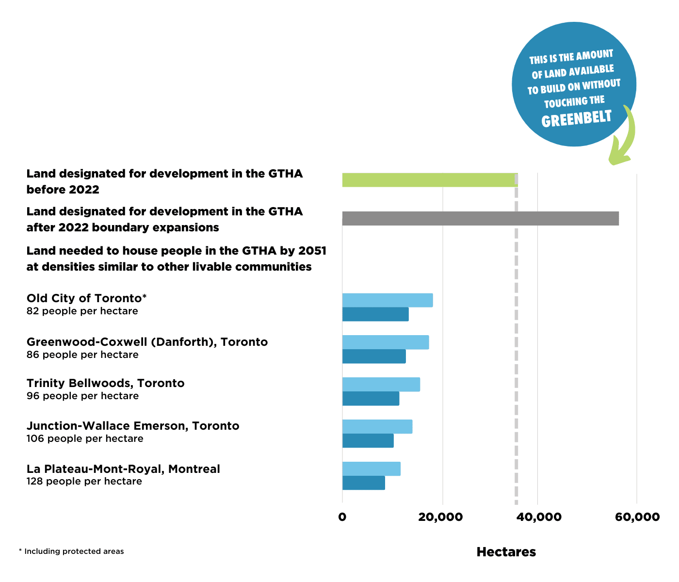
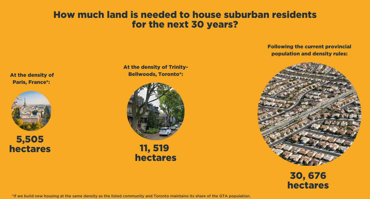
- Even if residents assigned by the Ontario government to the GTHA's future suburbs were housed at the modest densities of successful low-rise GTHA neighborhoods, like Trinity Bellwoods or Junction-Wallace Emerson, they would only consume approximately 15,000 ha (150km2) of land through 2051.2
- If Toronto were also to maintain its share of GTA population growth, as requested by environmental advocates, the land required for future low-rise GTHA suburbs through 2051 would fall to approximately 11,000 ha (110 km2).
- Simply developing the pre-2022 supply of already designated land in Hamilton, Halton, Peel, York and Durham at the same modest densities as the former City of Toronto would house more than 2.5 million "greenfield" (i.e., homes outside of existing neighborhoods and built up areas) residents, even if land for workplaces is factored in and natural areas, such as woodlots, ravines and wetlands, are kept off limits.3
- Thanks to decades of low-density sprawl, GTHA's existing built up areas will need to add roughly 10,000,000 (10.08 million) new residents just to achieve the population densities (roughly 100 residents per hectare) they'll need to become environmentally and fiscally sustainable.
- The amount of non-Greenbelt farmland and habitat now designated for sprawl is so large that developing it for housing would require Ontario to do so at densities far below the bare minimum required for cost-effective transit and servicing. That would mean Ontario is building fewer and more expensive homes.
1 Even if large lots developed within existing towns and cities were treated as greenfield, rather than intensification, the total would be roughly 17,000 ha.
2 If housed at the same density as the popular Trinity Bellwoods neighborhood, they would consume 15,709 ha (157 km2). At the density of the Junction-Wallace Emerson Neighborhood, they would occupy 14,151 ha (142 km2).
3 Factoring in bare minimum densification of existing neighborhoods, that means those municipalities could grow their populations by more than 5 million residents in total.
The graph below provides a comparison of the amount of land needed to build homes to meet ON's projected population growth until 2051 at the densities found in several livable, desirable urban communities in Canada
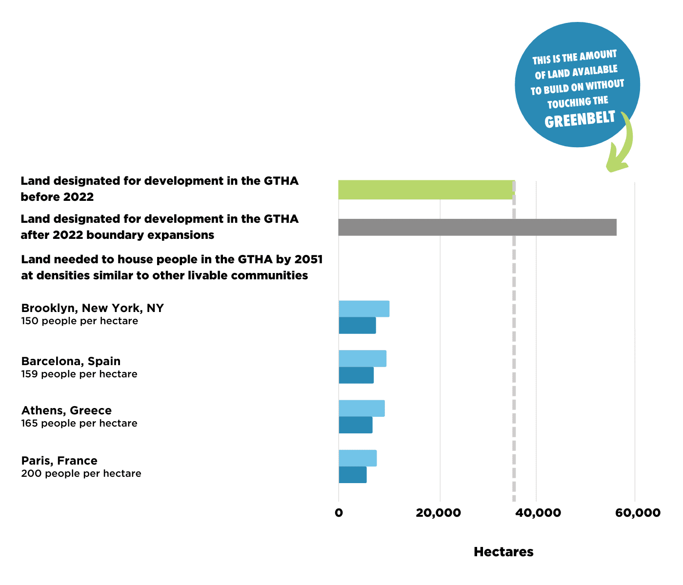
The graph below provides a comparison of the amount of land needed to build homes to meet ON's projected population growth until 2051 at the densities found in several livable, desirable urban communities in other countries

Take action and learn more about how the provincial government is making sprawl worse and destroying farms, forests and sustainable, livable communities!
LATEST NEWS
JOIN THE COMMUNITY

