Developing Disaster
Exploring the Species and Ecosystems at Risk in the Greenbelt’s Duffins Rouge Agricultural Preserve
Exploring the Species and Ecosystems at Risk in the Greenbelt’s Duffins Rouge Agricultural Preserve

The DRAP is a 17-square-kilometer area of farms, forests and wetlands situated on the east side of the Greater Toronto Area (GTA). This is an essential part of the Greenbelt that protects some of the most valuable agricultural land in all of Canada and supports the ecological integrity of the neighbouring Rouge National Urban Park (RNUP), the only national urban park
in Canada.
In December 2022, the provincial government stripped all legal protections for the DRAP and removed it from the Greenbelt, claiming the land was needed to build houses. Premier Ford made this decision despite massive public opposition and clear evidence that this area is ecologically sensitive and completely unnecessary to meet housing needs for either the Durham region or the province more generally.
Fortunately, the federal government has decided to take action. On March 21, 2023, the federal Minister of Environment and Climate Change Steven Guilbeault announced that the federal Impact Assessment Agency (IAA) would conduct a thorough assessment of the expected impact of any development within the DRAP area on species at risk, water quality, migratory birds, natural areas, the Rouge National Urban Park and biodiversity.
To help inform the design and execution of the federal study, we decided to gather and publish all the information that is currently known about the vulnerability of key wildlife species on the DRAP lands. Our resulting report describes the anticipated effects of development in the DRAP on species listed under the federal Species at Risk Act (SARA), fisheries habitat, migratory birds, other lands protected under provincial legislation and overall biodiversity. It draws on existing literature and, using data from a variety of sources, provides quantitative estimates, where possible, of the risks if development of the DRAP lands was to proceed.

species listed in the Species at Risk Act will suffer if development in the DRAP moves forward


One of North America’s best-known butterflies, the Monarch, has experienced steep declines, largely due to pesticides and the loss of its Milkweed host plants. Eleven of 14 Milkweed species in Canada are used by Monarchs, and the butterflies can be found in any habitat where these plants grow (typically meadows, overgrown agricultural fields and roadsides).
Although NHIC does not track Monarch occurrences in Ontario, data from the Ontario Butterfly Atlas indicate that Monarchs are relatively common in the GTA but occur in slightly lower abundance there than more rural parts of the province, possibly due to lack of habitat. Road casualties of Monarchs have been reported to increase with traffic volume and road width. Developing the DRAP would mean widening roads and introducing vehicle traffic to the landscape.
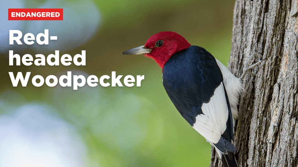
Red-headed Woodpecker (Melanerpes erythrocephalus)
Red-headed Woodpeckers were once abundant across North America, but today, intensifying agriculture, wildfire mitigation, competition with invasive nest predators and loss of habitat have driven them out of many areas. They depend on open deciduous woodlands, savannas, hedgerows and other semi-wooded landscapes, particularly with an abundance of large dead trees. In Ontario, remnant suitable Red-headed Woodpecker habitat disproportionately occurs in agricultural areas, making this species especially vulnerable to negative impacts caused by development of farmland around the GTA.
Tri-colored Bat (Perimyotis subflavis)
Tri-colored Bats are hibernating bats that have succumbed to White-nose syndrome. While they may also roost in man-made structures, they are more strongly associated with forests and may therefore be more sensitive than the Little Brown Bat to urbanization.
Development pressure adjacent to forests may affect bat populations in unknown ways, and the cumulative effects with white-nose syndrome could spell disaster for the Tri-colored Bat in the Rouge Valley.
Cerulean Warbler (Setophaga cerulea)
Cerulean Warblers reach the northern limit of their breeding range in Southern Ontario, where they are a rare summer inhabitant of deciduous forests, especially those dominated by oaks and hickories. They are area-sensitive but may nest in forest fragments as small as 10 ha.
The southwest corner of the DRAP, near the Rouge Valley and Amos Pond, is known to provide habitat for breeding Cerulean Warblers.
Redside Dace (Clinostomus elongatus)
The Redside Dace is an endangered minnow with a global range restricted to certain tributaries of the lower Great Lakes.
Redside Dace have specific habitat requirements: clear rivers and streams with a sand or gravel bottom less than 10m wide with slow-moving sections, pools and overhanging vegetation, and a temperature of 14-23 degrees Celsius. Because of the intense urban development that has occurred in the GTA, many sections of river no longer meet these requirements and Redside Dace have been pushed upstream to occupy headwater sections that have not experienced disturbance.
Yellow-breasted Chat (Icteria virens)
One characteristic that makes the DRAP so valuable ecologically is its concentration of species with Southerly ranges, and the Yellow-breasted Chat is a prime example of this.
This bird is abundant in the United States, but its Canadian breeding population is extremely small and confined to a few localities, one being the lower Duffins Creek valley.
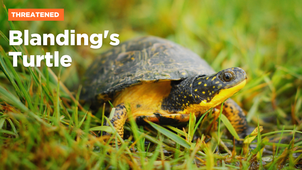
Blanding’s Turtle (Emydoidea blandingii)
Blanding’s Turtles require shallow water bodies with clean water and mucky bottoms and are restricted to a relatively small global range encompassing the Great Lakes lowlands and U.S. Midwest. Their Canadian population has been severely diminished by wetland loss, shoreline alteration and road mortality. In the GTA, Blanding’s Turtles occur in a few scattered locations, including the lower Rouge River and adjacent areas.
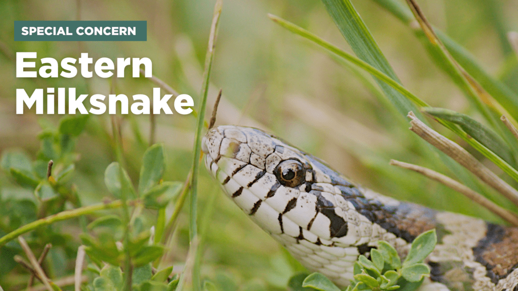
Eastern Milksnake (Lampropeltis triangulum)
This non-venomous member of the Kingsnake family is often mistaken throughout its global range for venomous lookalike species. In Ontario, it can be found in rocky outcrops, along forest edge and in rural areas around barns.
In addition to deliberate persecution by misinformed people, Milksnakes are threatened by road mortality and habitat loss.
Snapping Turtle (Chelydra serpentina)
Canada’s largest land turtle, the Snapping Turtle, utilizes all types of shallow water bodies with a soft mud or sand bottom and abundant vegetation, including roadside ditches and ephemeral wetlands.
Because of their habit of burrowing into gravel road shoulders for nesting, Snapping Turtles are frequently reported as road casualties. This is a serious problem for the species, whose long-lived, slow reproductive strategy means that the loss of even a few individuals can lead to population decline.
Yellow-banded Bumble Bee (Bombus terricola)
Native North American bumble bees have declined substantially across their range since the 1970s. Bumble Bee declines are likely a result of several factors working together, including pesticide use, habitat loss and climate change.
The Yellow-banded Bumble Bee is a habitat generalist, meaning that it exploits a wide range of open and semi-wooded environments for foraging and pollinates a variety of native wildflowers and crops. The Yellow-banded Bumble Bee has been found in the Rouge Valley and the southeastern corner of the DRAP.
So much is at stake with the provincial government’s attack on the Greenbelt, and the DRAP lands in particular. We hope this new report helps the public and the federal government with their important study of development impacts and ultimately leads to the protection of the DRAP.

Researched and written by Karl Heide with contributions from Tim Gray, Brittany Harris and Brendon Samuels. For a full list of acknowledgments, please download the report.
© Copyright April 2023 by ENVIRONMENTAL DEFENCE CANADA. Permission is granted to the public to reproduce or disseminate this report, in part, or in whole, free of charge, in any format or medium without requiring specific permission. Any errors or omissions are the responsibility of ENVIRONMENTAL DEFENCE CANADA.


