What you need to know
The Ontario government is asking for input to protect critical water systems that are under pressure from urbanization and climate change in the outer ring of the existing Greenbelt. The proposed study areas for expansion are based on where moraines, coldwater streams and wetlands overlap. They include:
- The Waterloo and Paris/Galt moraines in Waterloo Region, and Brant and Wellington counties
- The Orangeville Moraine in Wellington and Dufferin counties
- Several small moraines, including the Gibraltar and Singhampton moraines, along the brow of the Niagara Escarpment in Dufferin and Simcoe counties
- The Oro Moraine in northeast Simcoe County
- The Nottawasaga River corridor in Dufferin and Simcoe counties
- Important surface water and recharge features in southeast Simcoe County
- Catchment areas and wetlands west of Minesing in Dufferin and Simcoe counties
Protecting these areas is an important first step to ensure that water systems are secure for future generations.
But, vital water resources remain outside of the provincial study.

What we need to do
We need the government to protect water resources that are missing from its proposal. These include:
- The remainder of the Lake Simcoe drainage basin
- Significant recharge areas in Severn Sound & Carden Alvar
- Significant recharge areas in the Waverley Uplands
- The wetlands and recharge areas across Clearview
- The headwaters of the Humber, Don and Rouge rivers
- The watersheds of Duffins and Carruthers Creeks
- The south slope of the Oak Ridges Moraine and the Iroquois Shoreline along Lake Ontario in Northumberland County
- The Luther Marsh as a highly significant wetland
- The Grand River watershed in Brant County
A coalition of 120 groups across Ontario support Greenbelt expansion to further protect these vulnerable water systems throughout the Greater Golden Horseshoe.
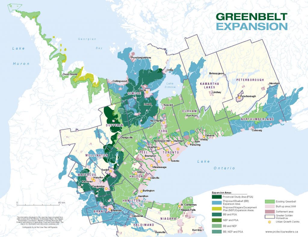
Below is a map that compares the proposed expansion area to the provincial study.
About the Map
The following map shows the overlap between the provincial study, the proposed Greenbelt expansion area (the “bluebelt”), and the proposed Niagara Escarpment expansion area.
- In dark green is the Provincial Study Area (PSA)
- In light blue is the Proposed Bluebelt Expansion Area (BB)
- In lime green is the Proposed Niagara Escarpment Expansion Area (NEP)
Zoom in to see if water resources in your region are outside of the provincial study.